Skip to content

Washington County Emergency Operations Center Moves to Enhanced Activation Due to Impending Severe Weather

HAGERSTOWN, MD (August 7, 2024) – The Office of Emergency Management continues to monitor Tropical Storm Debby and has raised the Emergency Operations Center (EOC) to Enhanced Activation status. The activation comes as scattered, slow-moving thunderstorms and the remnants of Tropical Storm Debby pose multiple threats to our area.

Today through Tonight

Meteorologists predict scattered slow-moving thunderstorms, which could result in isolated to scattered instances of flash flooding.

Thursday Morning through Thursday Afternoon

Bands of showers and thunderstorms will continue, increasing the risk of scattered flash flooding.

Thursday Evening through Friday Night

The remnants of Tropical Storm Debby are expected to pass through, bringing significant threats, including:

  • Heavy Rain and Flooding: Heavy rainfall may lead to flash flooding.
  • Tornadoes: There is a potential for tornadoes to form.
  • Gusty Winds: Winds could gust between 30 to 50 mph.
  • River Flooding: Rivers are at risk of flooding due to the heavy rain.

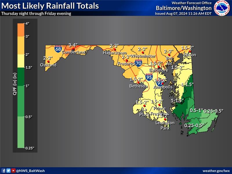
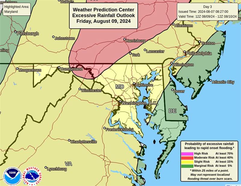
According to the Weather Prediction Center, the main surge of remnants from Debby will move through the area, with the heaviest rain near and west of the Catoctin Mountains. Scattered instances of flooding are possible, and localized higher amounts could result in significant flash flooding.

2-4” most likely near and west of the Catoctin Mountains.

Residents are urged to stay informed and take necessary precautions to ensure their safety. Please monitor local weather updates and follow any guidance from emergency services.

The Office of Emergency Management strongly advises all residents to avoid driving through high water. Flooded roads can be dangerous, and even a small amount of water can pose a significant risk.

Key Points:

  • Turn Around, Don’t Drown: Never attempt to drive through floodwaters. Just six inches of water can cause you to lose control of your vehicle, and a foot of water can carry away most cars.
  • Unpredictable Conditions: Floodwaters can hide numerous dangers such as debris, washed-out roads, and strong currents. What appears to be a shallow puddle could be much deeper and more hazardous than it looks.
  • Safety First: If you encounter a flooded road, turn around and find an alternate route. Do not take risks with your safety or the safety of others in your vehicle.

It is crucial to heed these warnings and make safe decisions during severe weather events. By avoiding flooded roads, you can protect yourself and your community.

For additional information, please contact Washington County’s Public Relations and Marketing Department at 240-313-2380 or [email protected].

###

Other news:

Tri-County Council for Western Maryland Launches Regional Survey to Improve Business Loan Programs, with Support from Washington County Business and Economic Development

Tri-County Council for Western Maryland Launches Regional Survey to Improve Business Loan Programs, with Support from Washington County Business and Economic Development

HAGERSTOWN, MD (July 22, 2025) – The Tri-County Council for Western Maryland (TCCWMD), with support from the Washington County Department…
Washington County Department of Water Quality Announces Smoke Testing for Maugansville Sewer System

Washington County Department of Water Quality Announces Smoke Testing for Maugansville Sewer System

HAGERSTOWN, MD (July 21, 2025) – Washington County Department of Water Quality will conduct a smoke test on the Maugansville…
Washington County Transit Awarded $2.8 Million in Federal BUILD Grant Funding to Advance Transit Facility Design

Washington County Transit Awarded $2.8 Million in Federal BUILD Grant Funding to Advance Transit Facility Design

HAGERSTOWN, MD (July 21, 2025) – Washington County Government is proud to announce that Washington County Transit has received exciting news that its competitive…